Boca Chica (Texas)
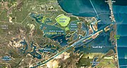
Area on the Rio Grande River DeltaBoca Chica is an area on the eastern portion of a subdelta peninsula of Cameron County, at the far south of the US State of Texas along the Gulf Coast. It is bordered by the Brownsville Ship Channel to the north, the Rio Grande and Mexico to the south, and the Gulf of Mexico to the east. The area extends about 25 miles (40 km) east of the city of Brownsville. The peninsula is served by Texas State Highway 4—also known as the Boca Chica Highway, or Boca Chica Boulevard within Brownsville city limits—which runs east–west, terminating at the Gulf and Boca Chica Beach.
Read article
Top Questions
AI generatedMore questions
Nearby Places

Rio Grande
Major river forming part of the United States and Mexico border

Bagdad, Tamaulipas
Former settlement in Tamaulipas, Mexico.
South Bay (Texas)

Ingham incident

SpaceX Starbase
SpaceX private launch site

Boca Chica Village, Texas
Unincorporated community in Texas

STARGATE
Radio-frequency technology facility in southern Texas
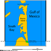
Brazos Island
Island in the United States of America